Academic and Professional Portfolio

Latest

Welcome

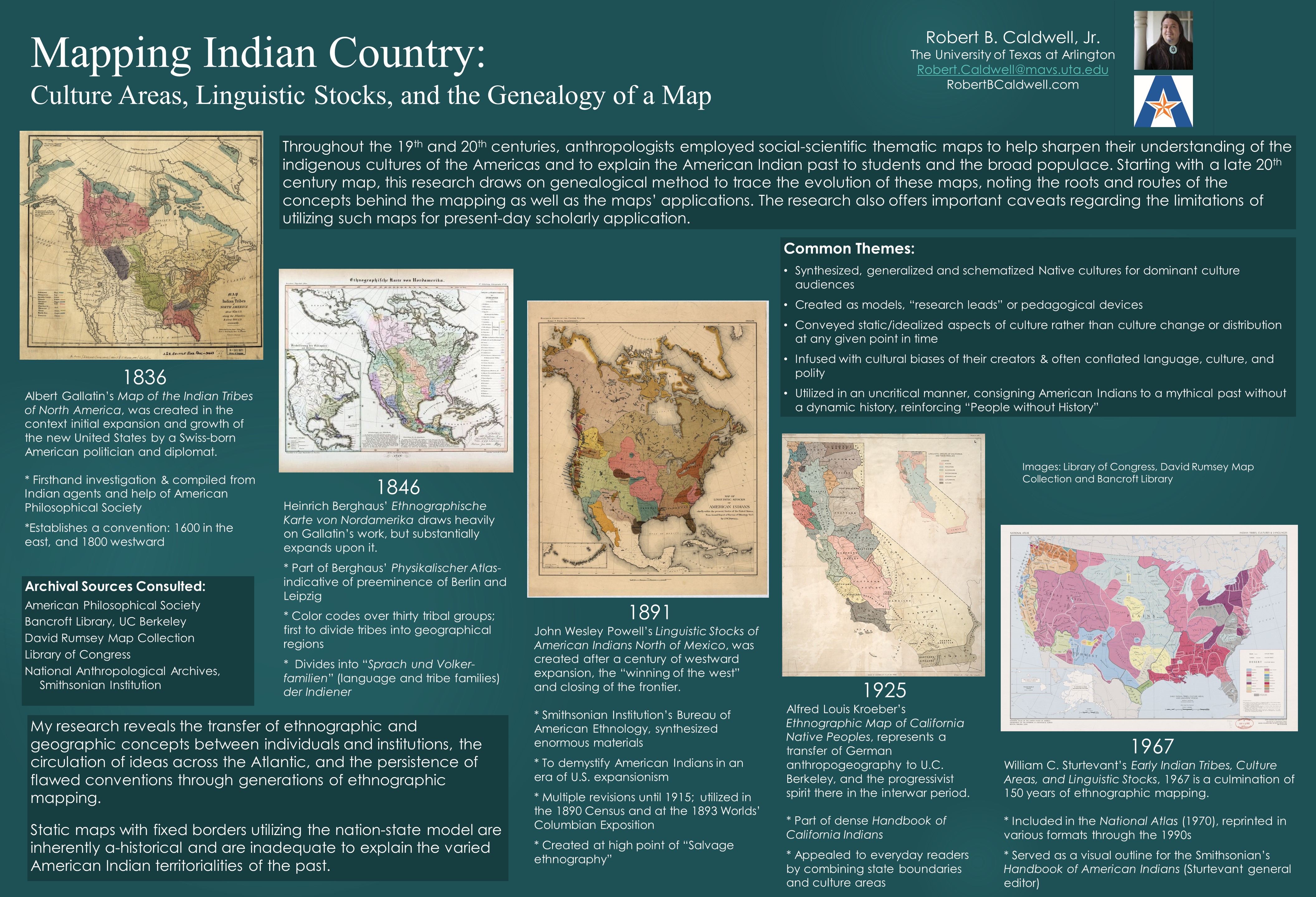
Robert Caldwell is an Assistant Professor of Indigenous Studies and Graduate Director of Indigenous Studies at the University at Buffalo (SUNY).

He is a Fellow of the Humanities Institute 2023-2024, and was a Fellow in the Ethics and the Common Good Faculty and Staff of Color Program 2022-2023 and a fellow in Race, Indigeneity, and Settler Colonialism in Global Perspective at the Institute for Holocaust, Genocide, and Memory Studies, 2021-2022. He was also the 2020-2021 Katrin L. Lamon Resident Fellow at the School for Advanced Research and Jay and a Deborah Last Fellow at the American Antiquarian Society.

He has worked as a Visiting Assistant Professor of Native American and Indigenous Studies at Hampshire College. He has taught American Studies at Brown University in Providence, RI and History at McNeese State University in Lake Charles Louisiana; his first tenure-track appointment was Assistant Professor of History and Geography at SOWELA Technical Community College. Prior to that he was a Library Digitization Specialist and Postdoctoral Research Fellow at the  University of Texas at Arlington where he completed the Doctorate in Transatlantic History in August 2018.

Robert’s interests include history of cartography, ethnohistory, foodways, the study of colonialism and imperialism, migration history, revolutions, and Native American and Indigenous Studies.

Click here to view Robert’s Curriculum Vitae . For more details, see the ABOUT section of this portfolio. Thank you for visiting.

ONLINE MEDIA

“Louisiana Choctaw” Louisiana Anthology Podcast (Forthcoming, recorded on March 18, 2024 ) https://louisianaanthology.blogspot.com/

Robert Caldwell “Powwows, Foodways, and Passing the Ball,” Bvlbancha Public Access November 16, 2021 https://www.youtube.com/watch?v=l820QjoJbIY

“Choctaw-Apache Foodways” Louisiana Anthology Podcast November 18, 2016

“Choctaw-Apache Foodways 2” Louisiana Anthology Podcast November 25, 2016

The River Bottom (Co-produced with Ava Lowery and John T. Edge) Southern Foodways Alliance, 2016

Image

#AHA20 Conference & Presentation

Caldwell AHA 51 LR (1)The American Historical Association Annual Meeting Jan 3-5 2020 New York City Robert B. Caldwell Jr. PhD, Robert.Caldwell@SOWELA.edu School of Arts & Sciences

The AHA’s annual meeting is the largest and most prestigious gathering of historians in the United States. This year’s meeting boasted over 300 sessions with some 4000 attendees from all fields and professions. As a representative of SOWELA, I increased our profile within the history community. I represented SOWELA at presentations, panel discussions, roundtables, receptions, and at the various receptions and informal social events. I met with historians from other community colleges to discuss best teaching practices for community college setting and the latest developments in the field.

The conference included an extensive teaching and learning track this year. Many of the sessions provided practical ideas for me to take straight back to the classroom. In addition to the many content-based panels, I attended two three-hour workshops. One workshop focused on syllabus design, student learning objectives, curriculum scaffolding, and refining assignments and benchmarks to improve outcomes. One panelist presented a method called “Decoding the Disciplines” (http://decodingthedisciplines.org), a process of identifying bottlenecks to “increasing student learning” by “narrowing the gap between expert and novice thinking.” This method might be helpful to our colleagues here at SOWELA and can be applied to any type of instruction. Another presenter offered a problem-based approach to syllabus construction. The panel organizers promised to share materials via Dropbox.

The K-16 educators’ workshop focused on the use of single primary source documents (photos, letters, objects) to alter our understanding of historical events and historical figures. The workshop included was headed by the director of the office of learning and innovation and the educational research specialist at the Library of Congress. The LOC offers classroom materials and professional development to help teachers effectively use primary sources from the Library’s vast digital collections in their teaching, including lesson plans that meet Common Core standards, state content standards, and the standards of national organizations at http://www.loc.gov/teachers/. Moreover, the conference included a Teaching Resource Fair with hands-on introduction to some of the latest resources for the history classroom.

I also had the pleasure to present at this conference. While I have presented at two previous AHA Annual meetings (in 2014 as a panel presentation, and in 2017 as a poster presentation), this is the first time I represented SOWELA. My presentation was part of the 3-5 minute “lightening round” where I profiled the latest research for my forthcoming book.

SOWELA has my deep appreciation for investing in my teaching and research. Supporting my attendance at this conference demonstrates a clear commitment to professional development and continuous learning, key factors contributing to the constant pursuit of academic excellence.

#AHA17 Poster Session

aha-meeting-posterrevisedfinal

Mapping Indian Country: Culture Areas, Linguistic Stocks, and the Genealogy of a Map

Throughout the 19th and 20th centuries, anthropologists employed social-scientific thematic maps to help sharpen their understanding of the indigenous cultures of the Americas and to explain the American Indian past to their students and the broad populace. While anthropologists initially depended on insider knowledge drawing on a range of American Indian informants and sources to create their maps, their works ultimately generalized and schematized American Indian cultures. The maps also conveyed the cultural biases of their creators. Over time, the map depictions ascribing territory and dividing political and cultural areas become understood more as established “facts” rather than models, “research leads” or pedagogical devices. These maps continue to be utilized by historians, anthropologists, cultural and regional geographers for classroom instruction and are popular illustrations in textbooks.

But these maps are too often employed in an uncritical manner. My research traces the evolution of these ethnographic, archaeological, and linguistic maps by performing a “genealogy” of William Sturtevant’s 1967 Early Indian Tribes, Culture Areas, and Linguistic Stocks a highly influential and popular map still in use today.  Tracing the cartographic, ethnographic, and intellectual history of the map reveals a palimpsest of scholarly debate, controversies, forgotten conventions and cultural assumptions not immediately clear on the face of the map.  Individually, each map is an artifact that reveals details about its creator(s), the period and circumstance in which it was created, and its intended use/ audience.

Taken together, these maps also offer an important window onto the roots and routes of scholarship behind the mapping of American Indians. One important trend is the sustained influence on the maps from German geographic thought. The earliest ethnographic maps are part of a transatlantic dialogue regarding American Indians and are directly or indirectly influenced by Alexander Von Humboldt. By the 20th century, the maps are thoroughly infused with ideas emanating from 19th century German nationalism, exhibiting a conflation of “blood” (ethnicity), land (with defined borders), and language, influenced by Friedrich Ratzel’s Human Geography (Anthropogeografie). Anthropologist Clark Wissler’s maps (not shown on poster presentation) evidence heavy borrowing from Leo Viktor Frobenius’ culture area concept (Kulturkreis) and Alfred Kroeber’ s works are influenced by Alfred Hettner’s state/regional geography (Länderkunde) introduced by Berkeley colleague Carl O. Sauer.

Over time, these ethnographic maps became increasingly complex, and by the twentieth century became so widely utilized as to be taken as fact. But the maps are filled with numerous dominant culture suppositions and have serious consequences for Indian Country.  A close and critical examination of the maps allows for more accurate utilization of them as a heuristic device and starting point for inquiry within the fields of anthropology, history, and Native American Studies. While the research concedes the pedagogical usefulness of ethnographic mapping, it also exposes the inherent a-historicity of utilizing static maps with fixed borders and the nation-state model to explain the multiple and overlapping American Indian territorialities of the past.

Archival Sources Consulted:

American Philosophical Society
Bancroft Library, University of California at Berkeley
David Rumsey Map Collection
Library of Congress
National Anthropological Archives, Smithsonian Institution

Praise for Choctaw-Apache Foodways

Choctaw-Apache Foodways explores the rich and complex food history and culture of the Choctaw-Apache Community of Ebarb in western Louisiana. The book is published by Stephen F. Austin State University Press and distributed by Texas A&M Press/ Texas Book Consortium. The publication was made possible in part by a publications grant from the Cane River National Heritage Area. The book is available online at  Amazon.com , at Barnes and Noble, or from Texas A&M Press/Texas book consortium.

ChoctawApacheFood

Choctaw-Apache Foodways provides a fascinating look at the distinctive history, culture, and foods of one of Louisiana’s Native peoples.  Robert Caldwell seamlessly incorporates his tribe’s culinary traditions within an absorbing ethnohistorical narrative that feeds your intellectual hunger, but leaves you craving some of that delicious food.  Luckily, there are recipes included—for food and for food sovereignty. -Brian Klopotek, author of Recognition Odysseys: Indigeneity, Race, and Federal Tribal Recognition Policy in Three Louisiana Indian Communities

Robert Caldwell’s book Choctaw-Apache Foodways fills in a gap in the documentation of Louisiana traditional cultures. From the garden to the table, it explores the importance of foodways as an ethnic marker for this cultural enclave.       -Maida Owens, Louisiana Folklife Program Director.

Robert Caldwell offers an insightful and delightful look at how foodways have dynamically contributed to survival and identity among the Choctaw-Apache people of Louisiana.  In a book written both to serve his own community and to inform a wider readership, he also demonstrates what can be achieved when comprehensive research methods of the scholar are skillfully blended with personal experiences and connections of the insider.  – Daniel H. Usner, Vanderbilt University.

ISBN-13: 978-1622880997

Museums and Sites Interpretation

Los Adaes

Los Adaes was the capital of Spanish Tejas on the northeastern frontier of New Spain from 1729 to 1770. It included a mission, San Miguel de Linares de los Adaes, and a presidio, Nuestra Señora del Pilar de Los Adaes.

As part of a previous summer internship with the Cane River National Heritage Area, I performed personal on-site interpretation at the visitors center and on the grounds of this National Historic Landmark site. I am in the process of creating a web portal to consolidate existing electronic resources on Los Adaes.

Above, right: extemporaneous interpretation at Los Adaes visitors center during geophysical investigations, Summer 2010

Williamson Museum

The Williamson Museum, located on Northwestern State University campus, includes a large collection of colonial and prehistoric pottery from northern and central Louisiana. Most notably, the museum houses the artifact collection for the Los Adaes archaeological site and the Clarence H. Webb collection of  prehistoric Caddoan archaeological sequence in Louisiana, Arkansas, Oklahoma, and Texas. It is also a state and federal repository for archaeological collections for the region. The ethnological collection efforts have concentrated on baskets and other crafts of the southeastern tribes.

I currently serve as docent under the direction of Hiram F. “Pete” Gregory on an as-needed basis. In addition to welcoming visitors, I participate in interpretive planning and exhibition development, cataloging  collections and curating artifacts.

New Orleans Neighborhoods

As a former resident of the Bywater, Marigny, and Mid City communities, and a student at the University of New Orleans,  I am familiar with the history and geomorphology of the Greater New Orleans Region. I have led numerous informal walking tours to all downtown neighborhoods and cemeteries using the Preservation Resource Center’s neighborhood brochures:

French Quarter

Faubourg Tremé

Faubourg Marigny

Bywater

St. Roch

New Marigny

Ethnography & Oral History

My project-thesis “Choctaw-Apache Foodways” depends on ethnographic fieldwork and oral history among the Choctaw-Apache of Ebarb community.

Gourds drying

Pepper Soup and Biscuits

Mr. Dick Sepulvado making tamales

I have written short, unpublished ethnographic papers on the following:

– Czech Cowboy culture

-Archaeologists and their relationship to the descendants of the people they study

-Native born American Buddhists

-Islamophobia in France, U.K., and Germany: What about the Czech Republic?

-French Market of New Orleans: A case of Continuity or Adaptive Reuse?

-Theravada Buddhism and Ethnic Identity in Texas

My hope is to continue researching the intersections of food and culture. I plan on writing a short article on the Zwolle Tamale Fiesta and ethnic identity in Sabine Parish. I have a research plan on a book on the relationship between grits and culture in the U.S. South, tentatively entitled, “How d’ you take your grits?”

I follow the ethical standards of the American Anthropology Association requiring informed consent, and the practices embodied in the Principles and Best Practices of the Oral History Association and the follow University requirements for Oral History under Human Subjects Institutional Review Board.

Archaeology

Archeology is not my specialty, but I have always been drawn to the discipline.  I am comfortable cataloguing  collections and curating artifacts. I have done  limited fieldwork as a crew member or volunteer at the direction of experienced archaeologists. I am not afraid to get dirty. I have the ability to read field maps and complete  field documentation and site maps.  I have a particular interest in NAGPRA repatriation.

Field

2010. Presidio Nuestra Señora del Pilar de los Adaes (16NA16). I coordinated volunteers doing wet screening, bagging and labeling of artifacts.

1998. Public Archeaology in the Treme (16OR148). I participated with excavation and dry screening.

Lab & Curation

2010.  Graduate Assistant, Williamson Museum under direction of Hiram F. “Pete” Gregory. Curating and inventory of  Williamson Museum’s permanent collections.

1999. Student summer curator for the Greater New Orleans Archaeology Program under guidance of Christopher N. Matthews. Sorting, labeling, photographing artifacs and assisting with editing archaeological reports.

Theory and Additional Skills

In Fall 2009 I  had a refresher on mapping, shovel testing, grid graphing, and the use of geophysical testing and GPS systems with Dr. Tommy Haley at Ft. Jesup archaeological site as part of his methods course. Also as part of this course I completed an archaeological proposal, “Rediscovering Willow Plantation” based on archival research and lidar maps.

Interpretation of Archaeological Reports

I am comfortable reading archaeological reports and integrating  archaeological data into my research projects.

Rediscovering old connections: Nacogdoches, Tx

A Summer 2010 trip to Nacogdoches to do research on descendants of Los Adaes brought me to the East Texas Research Center where I met with Peggy Jasso, a Texas genealogist specializing in old Spanish and mestizo families.I searched land records and poured through old Spanish documents translated in the E.B. Blake Collection.


I visited  rural communities and a number the older cemeteries.  In the course of visiting these communities with Dr. George Avery, an archaeologist at Stephen F. Austin University, we had the pleasure of meeting good contacts for follow up ethnographic fieldwork regarding life along the old  El Camino Real. Dr. Avery introduced me to the pre-historic and historic archaeology of the area. Before returning home, I  saw Old Stone Fort, Mission Delores and stopped for inspiration at  El Lobanillo, the site of Gil Ybarbo’s ranch on the Texas side of the Sabine River.


Documentation and Preservation

Historic American Buildings Survey

I completed a detailed Level IV  HABS report on 550-560 Front Street (DeBlieux) Commerical Building in Natchitoches. The report has been submitted to the Library of Congress.

Cemetery Preservation

I practice proper Cemetery care and grave marker cleaning methods. I learned these skills from Dr. Elizabeth Guin and put them to the test at American Cemetery in Natchitoches, LA. I also participated in the Oakland Cemetery tornado damage documentation for FEMA Assessment. November 2009.

After cleaning

Digitization

I completed the Historic Landmark District Survey Digitization Project for the Cane River National Heritage Area and City of Natchitoches planning office in early summer 2010.

I have the ability to digitize  and convert various forms of media, including:

* VHS to DVD

* Analog Cassette to digital audio file

* Paper to .pdf

* Photo, photo negative, or slide to .jpg